Cyclones Tauktae from the Indian Ocean are more likely to occur in the Bay of Bengal, especially in April or late April 2021. It mainly affects the coastal areas of Myanmar, Bangladesh and India.

Cyclone Tauktae Updates
12:49 (IST) May 16
Considering the prevalent weather conditions in, around, and enroute to Goa due to the very severe cyclone Tauktae, all airlines have cancelled their flight operations to and from Goa for today.
Goa airport director Gagan Malik
12:45 (IST) May 16
Cyclone Tauktae has intensified into a “very severe cyclonic storm” and is approaching the Gujarat coast: India Meteorological Department (IMD)
12:40 (IST) May 16
Goa’s Panaji witness the spell of Cyclone Tauktae
12:36 (IST) May 16
Union HM Amit Shah chaired a review meeting with the chief ministers of Gujarat, Maharashtra and Administrator of Daman and Diu and Dadra Nagar Haveli to assess the preparedness of states and central ministries to deal with the situation arising out of Cyclone Tauktae. (ANI)
12:19 (IST) May 16
Kerala is also likely to experience light to moderate rainfall at many places with heavy to very heavy falls at isolated places on May 16 and heavy falls at isolated places on May 17: IMD
11:59 (IST) May 16
Districts near the Konkan coast have been asked to prepare for the cyclone. The chief minister has taken stock of the matter. I’ve informed him about the rehabilitation work. We have given instructions for the preparation of large shelters in these areas.
Maharashtra relief and rehabilitation minister Vijay Wadettiwar
11:46 (IST) May 16
The water level in the sea has increased and it is expected to rise further by afternoon. All the fishermen are on alert to ensure their canoes are not pulled into the waters by strong currents: Local fisherman
11:39 (IST) May 16
Hundreds of electric poles are broken and scores of power conductors have snapped. Many high tension 33 KV feeders are down due to the falling of trees. Even the 220 KV lines bringing power to Goa from neighbouring Maharashtra have been damaged.
Goa power minister Nilesh Cabral
11:37 (IST) May 16
Cyclone Tauktae: Strong winds, rain in Goa; power supply hit
Gusty winds and heavy rains lashed several parts of Goa on Sunday morning due to cyclonic storm Tauktae, uprooting electric poles and affecting power supply in many parts of the coastal state, officials said. (PTI)
11:31 (IST) May 16
Cyclone Tauktae: 24 NDRF teams deployed in Gujarat
Our teams are prepared with all the necessary equipment and will be on standby. Wherever it is required, teams will be deployed. As many as 24 teams will take their place by 5 pm, with 13 teams from outside. Eight teams were called from Punjab and five from Odisha: NDRF deputy commandant Ranvijay Kumar Singh
11:14 (IST) May 16
I am in contact with district in-charge ministers and DCs of the affected districts to ensure rescue and relief operations.
Karnataka CM BS Yediyurappa
11:13 (IST) May 16
We are closely monitoring the cyclone situation in coastal areas, says Karnataka CM BS Yediyurappa.
11:00 (IST) May 16
Cyclone Tauktae is very likely to keep moving in north northwest direction. By late afternoon, its centre will be north-northwest of Goa. Gale winds and rainfall will continue for almost the entire day: India Meteorological Department (IMD)
10:53 (IST) May 16
Gujarat chief minister Vijay Rupani instructs state ministers to reach Bharuch with immediate effect to review the preparedness of the government to tackle possible cyclone situation. (ANI)
10:42 (IST) May 16
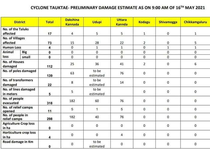
Due to cyclone Tauktae, heavy to extremely heavy rainfall was observed over 6 districts, 3 coastal districts and 3 Malnad districts in the past 24 hours. So far, 4 people have lost their lives, 73 villages affected: Karnataka State Disaster Management Authority (KSDMA)
Due to cyclone Tauktae, heavy to extremely heavy rainfall was observed over 6 districts, 3 coastal districts and 3 Malnad districts in the past 24 hours. So far, 4 people have lost their lives, 73 villages affected: Karnataka State Disaster Management Authority (KSDMA)
10:24 (IST) May 16
Districts near the Konkan coast have been warned for cyclone. The CM has taken stock of the matter. I’ve informed him about the rehabilitation work. We have given instructions to prepare large shelters in these areas.
Maharashtra relief & rehabilitation minister Vijay Wadettiwar
10:17 (IST) May 16
Maharashtra chief minister Uddhav Thackeray to brief Union home minister Amit Shah about state preparedness for cyclone Tauktae developing in Arabian Sea.
10:12 (IST) May 16
Cyclone Tauktae hits coastal parts of Goa.
10:07 (IST) May 16
NDRF teams deployed in Gujarat
10:06 (IST) May 16
NDRF teams have been deployed in the state in view of the cyclonic storm. As many as 24 teams will take their place by today evening, with 13 teams from outside.
NDRF Gandhinagar deputy commandant Ranvijay Kumar Singh
Here are five things you need to know about cyclone Tauktae:
1. The IMD has predicted that cyclone Tauktae, a name given by Myanmar which means “gecko”, will cause the maximum damage in Kerala. It has also issued a red alert for five districts of the state — Thiruvananthapuram, Kollam, Pathanamthitta, Alappuzha and Ernakulam.
2. An orange alert has also been issued for seven districts of Kerala — Kottayam, Idukki, Thrissur, Malappuram, Palakkad, Kozhikode and Wayanad.
3. Cyclone Tauktae would also lead to heavy rainfall in Mumbai, Thane, Goa and other parts of south Konkan over the next few days. According to the IMD, 64.5 mm to 115.5 mm rainfall in 24 hours is considered heavy.
4. As per IMD, heavy to very heavy rainfall is also predicted in parts of coastal and South Interior Karnataka from May 14.
5. Looking at the situation, the National Disaster Response Force (NDRF) has dispatched 53 teams in five states — Kerala, Tamil Nadu, Karnataka, Gujarat and Maharashtra — to handle any untoward situation caused by cyclone Tauktae.
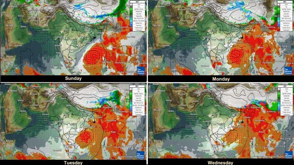
The IMD predicted heavy rainfall at isolated places over Uttarakhand, Punjab, Haryana, Chandigarh, Delhi and Bihar. The weather forecasting agency also said heavy rainfall is very likely in Sub-Himalayan West Bengal & Sikkim, Arunachal Pradesh, Assam, Meghalaya, Nagaland, Manipur, Mizoram, Tripura, Coastal, South Interior Karnataka, Tamil Nadu, Puducherry, Karaikal and Lakshadweep.
Current Position of Cyclone Tauktae

Quick Update on Cyclone Tauktae
NORTH INDIAN OCEAN AREA (MALAY PENINSULA WEST TO COAST OF AFRICA):
A. TROPICAL CYCLONE SUMMARY: NONE.
B. TROPICAL DISTURBANCE SUMMARY:
(1) THE AREA OF CONVECTION (INVEST 90B) PREVIOUSLY LOCATED
NEAR 6.6N 92.4E IS NOW LOCATED NEAR 7.2N 93.5E, APPROXIMATELY 292 NM
WEST-SOUTHWEST OF PHUKET, THAILAND. ANIMATED ENHANCED INFRARED
SATELLITE IMAGERY DEPICTS A DISORGANIZED DISTURBANCE WITH WEAK
FLARING CONVECTION THAT IS OFFSET TO THE WEST OF AN AREA OF BROAD,
ELONGATED, AND ILL-DEFINED LOW LEVEL CIRCULATION. A 301431Z AMSU-B
89GHZ MICROWAVE IMAGE REVEALS A LACK OF CONSOLIDATION AND FORMATIVE
CONVECTIVE STRUCTURE. HOWEVER, INVEST 90B IS IN A FAVORABLE
ENVIRONMENT FOR DEVELOPMENT WITH WARM (29-30C) SEA SURFACE
TEMPERATURES, ABUNDANT WESTWARD OUTFLOW, AND MODERATE (10-20 KNOT)
VERTICAL WIND SHEAR ALOFT. GLOBAL MODELS ARE SPLIT IN AGREEMENT THAT
INVEST 90B WILL MARGINALLY CONSOLIDATE AND INTENSIFY WITHOUT
REACHING TC STRENGTH WITH THE MODEL CONSENSUS TRACKING THE VORTEX
GENERALLY NORTH-NORTHEASTWARD TOWARD YANGON, MYANMAR. MAXIMUM
SUSTAINED SURFACE WINDS ARE ESTIMATED AT 10 TO 15 KNOTS. MINIMUM SEA
LEVEL PRESSURE IS ESTIMATED TO BE NEAR 1004 MB. THE POTENTIAL FOR
THE DEVELOPMENT OF A SIGNIFICANT TROPICAL CYCLONE WITHIN THE NEXT 24
HOURS REMAINS LOW.
(2) NO OTHER SUSPECT AREAS.
C. SUBTROPICAL SYSTEM SUMMARY: NONE.