Where is Dimapur

Dimapur is one of the largest city of Nagaland. As per the census of year 2011, the Dimapur municipality had a population of 122,834. The Dimapur city is the main gateway and commercial centre of Nagaland state. Located near the border with Assam along the banks of the Dhansiri River. Its main railway station is the second busiest railway station in the Northeast region of India.
Its Lat long coordinates are 25.92°North 93.73°East, it is 70 Kilomer North West at NH 29 from Kohima i.e capital city of Nagaland and 2186 KM north East side at NH 27 from Delhi the National Capital of India.

Where is Dimapur Situated

Name Dimapur
District Dimapur
State Nagaland
Country  India
Continent Asia
Area in KM 121 km2 (47 sq mi)
Elevation 145 m (476 ft)
Population 3,78,811(2011)
Population Density 2,558/km2 (6,630/sq mi)
Lat Long 25.8630° N, 93.7537° E
Literacy rate 85.44%.
Time Zone IST (UTC+5:30)
Area Code 03862
Zip Code Start 797 112
Languages English and Nagamese

Where is Dimapur, Located in Nagaland, India

Location Map of Dimapur, showing on Google map of Nagaland, India

Places to Visit

comming soon

Where is Payyanur in Kerala

Payyanur is one of the city of The Kannur District from the various major cities of Kerala, Payyanur is located on the the north end of Kannur District in the state of Kerala, an state of India, the Lat. Long. of Payyanur is 12.1051° N, 75.2058° E, and the height of this Town from sea level is 16 metres (51 feet), the nearest Trivandrum International Airport . Payyanur connected with other Indian cities by 1 major National Highways (NH-17,) and other State Highways.

Where is Payyanur located in India

Location Map of Payyanur showing on Google map of India

Information about  Payyanur

Name Payyanur
Nick Name
District Kannur
State Kerala
Country India
Continent Asia
Area
Population 68,711
Population Density 72/km2 (190/sq mi)
Lat Long 12.1051° N, 75.2058° E
Time Zone IST (UTC+5:30)
STD 91 4985
Zip Code Start 670307
Languages Malayalam
Rivers Perumba River.
Airports Bajpe Airport
Vehicle registration KL-13 & KL-59
Sex ratio 1159
Literacy 99.30%

Payyanur Places to Visit
Shanthi Cinemas-Payyanur

Sumangali Theater-Payyanur

Aradhana Theatre-Payyanur

Also know other major cities of India
Where is Kalol
Where is Mehsana
Where is Morbi
Where is Nadiad
Where is Navsari

Where is Gonda

Gonda city is located in the Eastern part of Uttar Pradesh, the Lat. Long. 27.13°N 81.93°E, and the height of this city from sea level is 120 meter, Gonda city is 133 km southern-eastern side from Lucknow i.e capital of Uttar Pradesh and 690 Km east from Delhi.

Information about Gonda

Name Gonda
Country India
Continent Asia
Area in KM 3,404 square kilometres
Population 3433919 (2011 )
Population Density 857 inhabitants per square kilometre (2,220/sq mi)
Lat Long 27.0374° N, 81.9535° E
Places to Visit shri shyam mandir, durga mata temple, old hanuman garhi, nagababa mandir, mata ka mandir, shivji ka mandir, naveen galla mandi, sankat mochan hanuman mandir, dukh haran nath mandir, new hanuman garhi, ma kali bhavani temple, st thomas church
Time Zone UTC+05:30
STD 05262
Zip Code Start 271001
Languages Telugu, Hindi, Marathi,
Mayor Shri Triloki Singh
Rivers Ghaghara river
Airports Gorakhpur Airport

Where is Gonda Located in Uttar Pradesh,India

Location Map of Gonda showing on Google map of Uttar Pradesh, India

History Gonda in Hindi

comming soon

Where is Ghazipur in Uttar Pradesh India

Ghazipur is one of the city of The Ghazipur District from the various major cities of Uttar Pradesh,Ghazipur is located Ghazipur District ,of Uttar Pradesh, an state of India, the Lat. Long. of Ghazipur is 25.5840° N, 83.5770° E. , and the height of this Town from sea level is 62 metres (203 feet)., the nearest Ghazipur Airport.,Ghazipur connected with other Indian cities by 1 major National Highways ( NH-19,) and other State Highways.

Where is Ghazipur located in India

Location Map of Ghazipur showing on Google map of India

Information about  Ghazipur

Name Ghazipur
District Ghazipur
State Uttar Pradesh
Country India
Continent Asia
Area 20 km2 (8 sq mi)
Population 121,136
Population Density 6,056/km2 (15,680/sq mi)
Lat Long 25.5840° N, 83.5770° E
Time Zone IST (UTC+5:30)
STD 0548
Zip Code Start 233001
Languages Hindi| Bhojpuri
Rivers Gomti,
Airports Ghazipur Airport
Vehicle registration UP-61
Sex ratio 902
Literacy 74.04%

Ghazipur Places to Visit

Suhasini Theatre
Durga Maa ji Ka Mandir
Shankar Mandir
Ganesh Mandir
Khoya Mandi Jheel
Old Church
Ma Kali Mandir
Jyotishi Mata Temple
Shubhra Theatre

History Ghazipur in Hindi

comming soon

Also know other major cities of India

Where is Bahraich
Where is Balrampur
Where is Barabanki
Where is Bareilly
Where is Basti

Where is Karachi

Karachi is located in the Sindh Region of Pakistan at the elevation of 8 meter from sea level with coordinates or lat long 24°51′36″N 67°0′36″E, nearest airport i.e Jinnah International Airport Karachi (IATA code: KHI) east of the city center in a distance is 19.2 k/m.

Where is Karachi located in Pakistan

Know where is Karachi located in Pakistan on Google Map


Information about where is karachi situated

Name Karachi
Country Pakistan
Continent Asia
Came in existence 1742 (As per Dutch document)
Previous name any Kolachi(Till 1742)
Area in KM 3,527 km2
Area in miles 1,362 sq mi
Population 24,300,000 (Est 2016)
Population Density 42.5 people per km2 (2016)
Lat Long 24°51′36″N 67°0′36″E
Name of Monuments Ziarat Residency, Pakistan Monument, House of Abdus Salam, Allama Iqbal’s Tomb, Allama Iqbal Museum, Islamic Summit Minar, Minar-e-Pakistan, Khaliq Dina Public Hall, Quaid-e-Azam’s Mazar, Quaid-e-Azam House Museum, Birthplace of Muhammad Ali Jinnah
Places to Visit Dolmen Mall Clifton, Mazar-E-Quaid, Mohatta Palace Museum, Frere Hall, Boat Basin, Zainab Market, Hilal Park, Ocean Tower, Park Towers, Bin Qasim Park Clifton, Quaid-e-Azam House Museum, Tooba Mosque, Bin Qasim Park, Safari Park
Time Zone GMT+5.
STD Code +(92)21
Zip Code Start 74200 (GPO)
Languages Urdu, Sindhi, Punjabi, Pushto, English
Mayor Sajjad Hussain Abbasi
Transportation Taxis, car, city bus, Airport
Rivers Malir River and Lyari River
Lakes Hub Lake and Haleji Lake
Airports Jinnah International Airport

Know Where is Saragarhi

Path Map of Cyclone Asani

During the early hours of Sunday, May 8, the potent system based in the Bay of Bengal intensified into a Cyclonic Storm, effectively transforming into Cyclone Asani. From here on, it is expected to gather more strength and evolve further in the next 24 hours.
Current Wind Speed 50 knots / 58 MPH

Max Predicted Wind Speed 50 knots / 58 MPH at May 11, 2022 5:30am


A rapid intensification
The transformation of this system into a cyclone occurred much earlier than previously expected. Initial predictions had indicated that the deep depression would not strengthen into a Cyclonic Storm until the evening hours of Sunday.

However, as per the India Meteorological Department’s (IMD) latest update, the cyclone had already formed sometime around 2:30 am on Sunday.


Source-https://www.cyclocane.com/asani-storm-tracker/

Furthermore, as of 5:30 am, it was located over southeast Bay of Bengal — about 450 km west-northwest of Car Nicobar (Nicobar Islands), 380 km west of Port Blair (Andaman Islands), 970 km southeast of Visakhapatnam (Andhra Pradesh) and 1030 km south-southeast of Puri (Odisha).

Cyclone ASANI storm path from JTWC

Time Speed Location Status
May 9, 2022 5:30am 55 knots 14.0, 86.1  
May 9, 2022 5:30pm 50 knots 14.8, 85.1  
May 10, 2022 5:30am 45 knots 15.5, 84.5  
May 10, 2022 5:30pm 45 knots 16.3, 84.1  
May 11, 2022 5:30am 40 knots 17.0, 84.0  
May 12, 2022 5:30am 40 knots 18.1, 84.7  
May 13, 2022 5:30am 35 knots 20.1, 87.4 dissipating
May 14, 2022 5:30am 30 knots 22.8, 90.9 dissipated

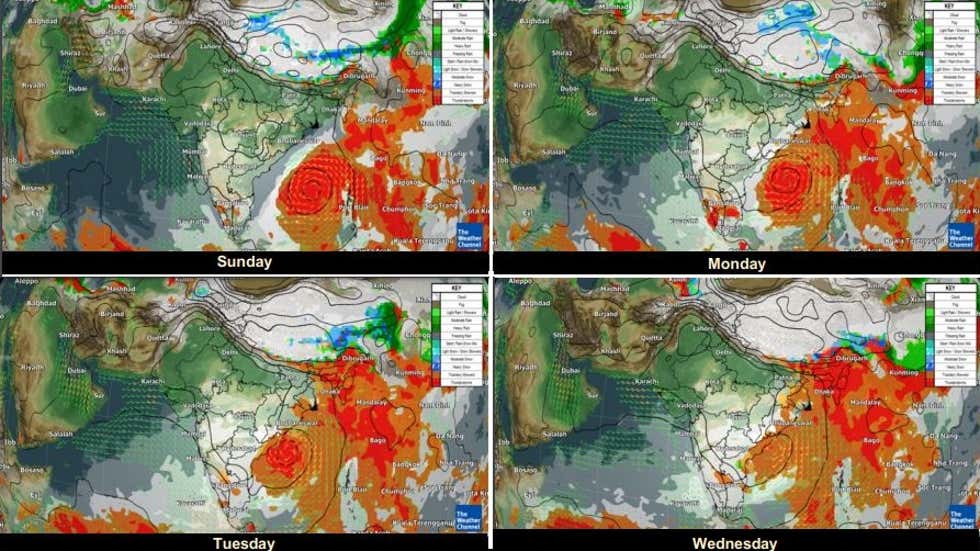
From here on, the system will continue to move northwestwards, and gradually intensify into a Severe Cyclonic Storm over east-central Bay of Bengal by the early hours of Monday, May 9. This is when the system is expected to be at its strongest, as it may pack wind speeds up to 60 knots (111 km per hour).

Thereafter, its northwestward movement will continue, and by Tuesday evening, Severe Cyclone Asani will reach west-central and adjoining northwest Bay of Bengal — off the coasts of North Andhra Pradesh and Odisha. It is then likely to recurve north-northeastwards and move towards northwest Bay of Bengal, off the Odisha coast.

Landfall unlikely over Odisha, Andhra Pradesh
According to IMD Director-General Mrutyunjay Mohapatra, the aforementioned recurving of the system in the northeastern direction may end up sparing the states of Odisha and Andhra Pradesh from the possibility of a cyclone landfall.

In fact, he has opined that this movement may result in Cyclone Asani moving parallel to India’s eastern coast.

The Weather Channel’s met team has added that while this parallel movement continues, the system may start losing steam by Wednesday night or Thursday morning, and begin its gradual deintensification process.

Expected impact over East India
As for its impact on East India, the IMD has predicted isolated heavy rains over coastal Odisha and north coastal Andhra Pradesh from Tuesday evening onwards, while similar conditions will engulf coastal West Bengal starting Wednesday.

The sea conditions will remain rough throughout, and therefore, the fisherfolk have been advised not to venture into the waters, especially in central Bay of Bengal from May 9-10 and northwest Bay of Bengal from May 10-12.
Source- https://weather.com/en-IN/india/news/news/2022-05-08-cyclone-asani-to-intensify-into-severe-cyclonic-storm-on-may-9

Path map of in fa fabian

The Philippines was hit by typhoon In-Fa and expected to make landfall in the eastern or northeastern coastal areas of China. Typhoon In-fa, known in the Philippines as Typhoon Fabian, is an active tropical cyclone in the East China Sea, threatening China.

Keypoints

The storm has exacerbated and played a part in starting the 2021 Henan floods. Since 17 July 2021, China’s Henan province has been affected by severe flooding, caused by a period of prolonged heavy rainfall.
According to projections, In-fa would beat Typhoon Fitow of 2013 as the costliest typhoon to strike China, and the third costliest typhoon on record (a total of $14.7 billion) when adjusted for inflation.
What is Cyclone?
Cyclone is a storm where the low-pressure zone is surrounded by a high-pressure zone. Air moves inward from high to low-pressure zone and under the influence of Coriolis force whirls anticlockwise in Northern Hemisphere and clockwise in Southern Hemisphere.

* High-Pressure Zone: High-Pressure Zone is a region where the atmospheric pressure at the surface of the planet is higher than its surrounding environment.

* Low-Pressure Zone: Low-Pressure Zone is an area where the air pressure is lower than that of surrounding areas.

How a Cyclone is formed?
The formation of cyclones usually takes place in the low-pressure areas. These are formed over masses of warm water (like ocean, sea, etc.) near the equator. The rising of warm moist air begins the cyclonic process. When the warm air starts rising, the cooler air rushes in to fill the void left by the warm air. The warm, moist air cools as it rises higher into the air and forms clouds. As the process continues it begins to pick up speed and eye forms in the center. The eye is the lowest pressure spot in the storm (cyclone). This process is officially known as cyclone when wind speeds reach 74 mph.

When the cyclone hits the land, this process begins to slow due to the absence of warm air. However, this takes an extraordinary amount of time to dissipate completely.

Types of Cyclone
Characteristic Tropical Cyclone Polar Cyclone Mesocyclone
Nature
Tropical cyclones are closed air circulation around a low-pressure center.
This wind movement is caused by atmospheric disturbances coupled with the earth’s ‘rotation.
Polar cyclones are also known as Arctic Cyclones.
These are large areas of low pressure and are usually 1,000 to 2,000 kilometers wide in which the air is moving in a spiral counterclockwise fashion in the northern hemisphere.
A mesocyclone is a vortex (spiral) of air within a convective storm (approximately 2 to 10 miles in diameter).
It is the air that rises and rotates around a vertical axis, normally in the same direction as low-pressure systems in a given region.
Region of Occurrence
It happens over tropical ocean regions and of two types- Hurricanes and typhoons.
Hurricanes are found in the Atlantic and Northeast Pacific region, whereas Typhoons are found in the Northwest Pacific region.
It usually occurs over Polar Regions of Siberia, Greenland, and Antarctica.
It is strong during the winter season.
These types of cyclones are followed by the rotating air inside the thunderstorm.
Mostly occur in the North American region.
Tropical Cyclones and their Regional Names
Tropical Cyclones have a diameter of 100 to 500 kilometers. These are known by different names in different regions such as:

Characteristics Hurricanes Typhoons Cyclones Tornadoes
Region of Occurrence
These are tropical storms in the West Indies and the Gulf of Mexico which usually occur in August-September.
These may bring thunderstorms and torrential rain.
These are tropical storms in the China Sea along with China and Japan coast.
These are similar to Hurricanes of the USA which may bring thunderstorm and torrential rain.
These are tropical low-pressure system occurring at the Indian coast in Bay of Bengal and the Arabian Sea.
These also bring thunderstorm and rain.
These are also known as Twisters (mainly in the USA). These are very intense and occur in Mississippi Missouri basin in the USA.
These are accompanied by dark funnel-shaped clouds.
Velocity of Wind
Wind blows with 160 to 180 kmph
The wind blows with speed to 160 to 180 kmph.
These whirl with a wind speed of 280 to 300 mph.
Winds are very violent with a speed of 350 to 500 mph.
Willy-Willy: These are the tropical storm which originates in the coast of North-West Australia

*Anticyclones: These are high-pressure belt surrounded by the low-pressure belt. The wind blows outward in the clockwise direction in Southern Hemisphere.

Significance of Cyclones
The Cyclones levels down the inequalities of pressure and wind movement over the globe.
They play an important role in the complex process of heat exchange between various latitudinal zones.
Cyclones have an effect over the phenomenon of precipitation, more so in the mid-latitude regions, by lifting up the moist air from oceans and carrying it into the surrounding landmasses.

Where is Belur Karnataka

Belur was the early capital of the Hoysala Empire. Belur along with Halebidu about 16 km away is one of the major tourist destinations in Karnataka. According to inscriptions discovered here, it was also referred to as Velur or Velapuri. It was the early capital of the Hoysala kings in 11th-century and remained a second capital through the 14th-century. The city was so esteemed by the Hoysalas that it is referred to as “earthly Vaikuntha” (Vishnu’s abode) and “Dakshina Varanasi” (southern holy city of Hindus) in later inscriptions.

The mineral beryl and the element beryllium might have gotten their names from this city, world famous Chennakeshava Temple is Located here.

Fact about Belur

City Belur
District Hassan
State Karnataka
Country India
Continent Asia
Area NA
Population 28,754
Population Density NA
Lat Long 13.1629°N 75.8571°E
Time Zone IST (UTC+5:30)
STD (0)8177
Zip Code Start 573115
Languages Kannada
Rivers NA
Airports Nearest airport is 200 kilometres (124 mi), Bengaluru (IATA Code: BLR)
Vehicle registration KA-13/ KA-46
Sex ratio NA
Literacy NA
Nick Name Dakshina Varanasi

Where is Belur Located

Where is Ayodhya Uttar Pradesh

Ayodhya is one of the city of The Ayodhya District before the creation of Ayodhya as District this city comes in faizabad District, from the various major cities of Uttar Pradesh, Ayodhya is located Ayodhya District, of Uttar Pradesh, an state of India, the Lat. Long. of Ayodhya is 26.80°N 82.20°E. , and the height of this Town from sea level is 93 m (305 ft), the nearest Airport is faizabad (Where is Faizabad) airport, Ayodhya connected with other Indian cities by 1 major National Highways ( NH-135A) and other State Highways with Lucknow (134 km), Gorakhpur (132 km), Jhansi (441 km), Allahabad (166 km) (Where is Prayagraj), Sravasti (109 km), Varanasi (209 km) and Gonda (51 km).

Where is Ayodhya Located

Aydhya Location on Google Map

Facts about about Ayodhya City

Name Ayodhya
District Ayodhya
State Uttar Pradesh
Country India
Continent Asia
Area 79.8 km2 (30.8 sq mi)
Population 55,890
Population Density 700/km2 (1,800/sq mi)
Lat Long 26.80°N 82.20°E
Time Zone IST (UTC+5:30)
STD (0)5278
Zip Code Start 224001
Languages Hindi
Rivers Saryu
Airports Nearest airports are Faizabad 5 km away, Amausi in Lucknow 134 km away, Allahabad 166 km away
Vehicle registration UP-42
Sex ratio 997
Literacy 78.10%

Places to Visit in Ayodhya

  • Prayagraj
  • Kanak Bhavan Temple
  • Brahma Kund
  • Ram ki Paidi
  • Ayodhya Ghaat
  • Hanuman Garhi temple
  • Vijayraghav Mandir
  • Sant Sri Paltds Temple
  • Ram Janmabhoomi
  • Where is Chennai

    Chennai is one of the city from the various major cities of Tamil Nadu, Chennai is located in the eastern part of Tamil Nadu, an state of India, the Lat. Long. of Chennai are 13°5′N 80°16′E, and the height of this city from sea level is 6 meters, 0 km side from Chennai capital of Tamil Nadu and 2206 km South side from Delhi, the capital of India, Chennai connected with other Indian cities by four major National Highways (NH) that originate in the city. They are NH 4 to Mumbai (via Bengaluru, Pune), NH 5 to Kolkata (linked via NH 6) (via Visakhapatnam, Bhubaneswar), NH 45 to Theni (via Villupuram, Tiruchirapalli, Dindigul) and NH 205 to Madanapalle (via Tirupati). Chennai is connected to other parts of the state and the Union Territory of Puducherry by state highways.

    Where is Chennai located in India

    Location Map of Chennai showing on Google map of India

    Information about Chennai

    Name Chennai
    District Chennai, Kanchipuram and Tiruvallur[
    State Tamil Nadu
    Country India
    Continent Asia
    Area in KM 426
    Elevation 6 m (20 ft)
    Population 7,088,000
    Population Density 26,903 persons per km2
    Lat Long 13°5′N 80°16′E
    Literacy rate 88%
    Time Zone IST (UTC+5:30)
    Area Code 9144
    Zip Code Start 600xxx
    Languages English, Hindi, Tamil

    Places to Visit in Chennai

    • Marundeeswarar Temple
    • Kapaleeshwar Temple
    • Besant Nagar Beach
    • Marina Beach
    • Arignar Anna Zoological Park
    • Elliot’s Beach
    • Breezy Beach
    • Kovalam Beach
    • VGP Golden Beach
    • Chetpet EcoPark
    • Sri Parthasarathy Temple
    • Tirumala Tirupathi Devasthanam
    • San Thome Church
    • Vadapalani Murugan Temple
    • Madras Crocodile Bank